That's exactly correct!
Unexcited about
yet another Stalingrad map? That's probably understandable...
However, I'm trying to spice things up by keeping it as close to reality as possible, in a way that as far as I know has not been done before.
It's the Northern aka the Factory District, encompassing the Barrikady Factory, the Red October Factory, the so-called Tennis Racket, Mamayev Kurgan, the Stalingradsky Flight School, the Commissars' House, a bunch of lesser known landmarks and the vast suburbs that housed the workers for these factories.
The Tractor Factory, the city centre (featuring the train station, Univermag, etc.), grain elevator etc. are therefore outside of the scope of this map.
I spent a good amount of time researching the topography of the factory district. The factory layouts, the railways, important buildings and landmarks, major ravines, are all taken from historical maps, supported by aerial photos and some modern maps as well. Inspired by Simeo's Mareth Line, all landmarks will be named on the map thanks to the placeable letters that came with GZM9. Never heard of the Silicate Plant or the Lazur Chemical Factory? You might, soon...
After giving another user on here some
needlessly nit-picky advice on the weather in Berlin 75 years ago, I reflected on my own project and realised that the battle I'm portraying started in August and went on until it was -30° and the battlefield had turned into an icy hell. Obviously, that's impossible to portray in a single map in BK, but I am trying to incorporate the changing seasons as the player moves forward on the map (i.e. the starting area will look like late summer, and the areas by the river will look like full-on autumn). Hence the need for the alternate tileset. There won't be any snow though, that would just look weird.
Below is my cheat sheet, the original is a whooping 10,000x6,600 pixels, 50mb in size... the aerial photos on the right have a crazy amount of detail and are super useful. I just zoom in on which ever part I need. I've found this to be more efficient than to have all of these saved as separate images.

The third map from the top left is actually this one, and is in turn just a small part of the original map used by German high command in 1942:

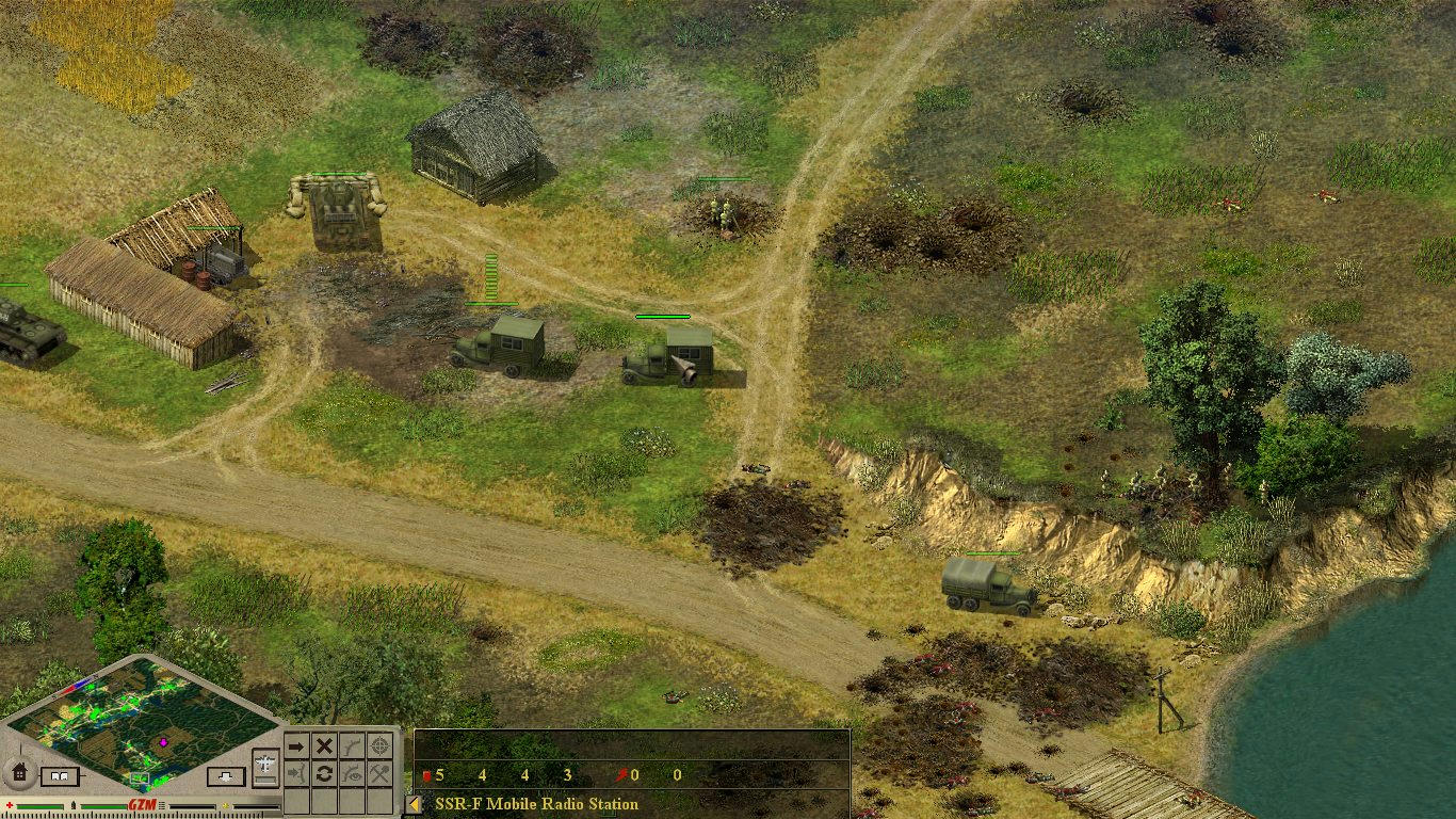
Compare that to the current state (note that some of the buildings aren't in their final positions yet):

Obviously, it's not 100% accurate, but I'm pretty happy with the results so far.
The tennis racket (yes that's what the Germans named the railway circle on the top right) looks pretty skewed, this happened because I was basing myself on the mini map in the editor which was apparently not perfectly rectangular at the time, thus leading to the circle looking weird as well. Will get reworked at some point!
Buildings and roads: 80% done
Objects and flora: 5% done
Units and scripts: 0% done (I might outsource this part again)
ETA: late 2021..?
I've learned a lot from
my previous 32x32 map and I hope that certain improvements to the workflow will speed this process up. On the other hand, this task is even more daunting than the previous one. I absolutely plan on giving this map the same attention to detail than the other one, so let's just see how it goes... I would have never started this project if not for COVID and all the free time and sitting around at home that brought along. Any changes to that and this may be stuck in WIP forever. But I love working on this, so the time will never be fully wasted.
As I said, I wasn't gonna "tease" this project at all and just upload it if and when it's done, but given the help you've provided me, you deserve to know what it's for.
I'm actually immediately retracting this statement, looks like I'll have to go a bit further down this rabbit hole than I anticipated. I'll just pop in here for questions as they come up


![[BMG]Neutro Avatar](http://storage.proboards.com/2952485/avatar/oRRwK0HLJTeXfLpVlTma.jpg)


 that is why we are behind